Thursday 30 May 2013

Playing tourist in my own city Pt 2

After our tour of the Elgin and Winter Garden Theatres, we came out onto Yonge Street and caught sight of this attractive renovated building, the Dineen Building, at no. 140 Yonge St, another Doors Open site.  This used to be the home of the Dineen Company, a prominent hat and fur company.  It has undergone extensive renovations but many of the historic features are preserved.  You can check this interesting article on the Urban Toronto site to see some photos of the interior during renovations.  There was a lineup to get in when we were there so we saved it for another year.  But judging from the pictures, it's well worth a visit.


Continuing on our trek south, we visited One King West, originally the old head office of the Toronto Dominion Bank, now a luxury hotel.  This is the grand staircase that took us up to the grand banking hall.


 Grand banking hall set up for a wedding.


This is the vault entrance.  This was once the largest bank vault in Canada.  The door weighed over 40 tons but was apparently so well-made that a paper-clip dropped in the opening will stop the door from closing. 


Our next stop was lunch at the MarchĂ© in BCE Place.  The highlight of the lunch was the berry flan and the stroll through BCE Place, always spectacular and particularly so when I had my camera with me.


This rather reminded me of a similar building in Milan.


For the month of May, there is a photo art installation "Pyramid" by James Nizam as part of the Scotiabank Contact Festival.  You can read about the art on the Contact website
You see below my own photo of the reflection of the arches in the glass entrance.  Truly amazing - the reflection of the reflection on the glass - the juxtaposition of layers of reality and illusion.  Astounding!


This was not the first time we visited BCE Place but every time we did, we couldn't help but be awed by the artistry of the design.  For a change of pace, we headed towards the more stolid Canada Life Building, a few blocks north, at Queen and University.  In front of the building, I noticed this graceful statue on top of a granite column, a memorial of the Boer War.  Forty years in Toronto, and I have never actually "seen" this winged statue.


This Pelican statue is the only thing I liked in the Canada Life Board Room.


Clearly I wasn't the only one who thought this portal worth photographing


Another one to add to my collection of elevator doors


View from the 17th floor.  I was mildly disappointed because I thought we had lined up to take the elevator to the open observation deck.  But it turned out it was not outdoors.  These shots of the city were taken behind glass.  View of the the Ontario College of Art, designed by British architect Will Alsop.


Looking south towards the CN Tower


East towards the old and new City Halls, Nathan Phillips Square


The Trump Tower in front of the Bank of Nova Scotia Building (the most amazing thing in all this is that I didn't know this was the Trump Tower.  But I walked by the Bank of Nova Scotia Building earlier and recognized it.  I did a Google search for "Bank of Nova Scotia Building behind" and identified the Trump Tower that way.  I'm completely in awe of Google - if I had the money, I'd buy its stock.  It's going to take over the world!


Monday 27 May 2013

Playing tourist in my own city

The annual Doors Open Toronto enabled me to play tourist for a day.   When we travelled abroad, we would go madly looking for beautiful architecture and unique buildings - in fact these are in abundance in our own city.  The old CIBC building in Commerce Court North and the Elgin and Winter Garden Theatres are two such buildings within a 10 minute walk of each other downtown.

Staircase to the lobby of Commerce Court North from the basement mall
Stunning lobby 


The limestone building was completed in 1930 as the headquarters of the Canadian Imperial Bank of Commerce and was for three decades (until 1962) the tallest building in the British Commonwealth


Door handle details

The front door portal
Walking north a few blocks from 25 King West up Yonge Street at No. 189 is an unassuming building that houses the Elgin and the Winter Garden Theatres.  You would never have guessed what the interior looks like when you see the building from the outside.  


Once you're inside though, you'll realize that you are in a very special building.  

The faux marble is everywhere but it created the ambiance for the hallways and inside the Elgin Theatre itself.
We have gone to the Elgin many times as it is the home of the baroque opera company Opera Atelier but we have never gone as "tourists", have never taken pictures of the inside, have never gawked!  In general, we behaved ourselves as concert goers.  Visiting it during Doors Open was another experience all together.

The ornate boxes


The balcony and the ceiling above
Seven stories above the Elgin Theatre is the Winter Garden Theatre.  These are the last surviving Edwardian stacked theatres in the world.   We walked up several flights then up three sets of escalators to get to the The Winter Garden Theatre.  It has a very special look - literally that of a winter garden, with trees for columns and millions of leaves, faux, dried or otherwise preserved. 


The Doors Open crowd listening to the history of the theatre and descriptions of how the leaves were preserved.  Someone asked how they are cleaned - response is they build scaffolding in order to do the cleaning.  You can imagine they won't be cleaned every month!

The boxes are very differently decorated from the ones at the Elgin


The hand painted fire screen

A closeup look at the tree and the leaves
It was a great way to spend a Sunday - exploring my own city!  After lunch we visited One King West, BCE Place and the Canada Life Building.  More in the next post.


Saturday 25 May 2013

Off Road Adventure

When I read about Coal Mine Canyon on Tripadvisor, I knew I would like to see it and that it might not be easy to find but I didn't bank on a real off road adventure.  A blog site I came across gave us the GPS coordinates for the canyon and told us that it was off Hwy 264 approximately 16.4 miles south of Tuba City.  Then another post said it was much more than 16 miles.  The blog site also had a map of this location.  All this information didn't prepare us for the fact that there were absolutely no signs to tell us which dirt road to take off the highway to get to the canyon.  That stretch of highway was on Navajo reservation land and there were fences beside the highway.  So we looked for a break in the fence quite a bit after the 16 mile point and took our chances.  (For those of you who thought you might try this, the coordinates for the entrance to the dirt road are N35.98621 W911.00059)

It was a little adventurous for us, especially when we didn't know whose land we were on, if we were on the right track or headed in the right direction.  Several times we thought of turning back but we didn't.  The dirt road just went on and on and we came to a point where the track climbed steeply and then dropped - we couldn't really see beyond the top of the hill until we got over it and could very well had dropped down a cliff.   But our sense of adventure egged us on.  We were also lucky we didn't fall off the edge.  We found ourselves at the top of a hill and looking down, canyon land stretched out ahead to the horizon, but no other hint of civilization.


This was an encouraging view and there were other car tracks.  So we kept going and figured it would be safe to follow other tracks that went to the edge of the canyon.  Even then, we played it safe.  We were conscious of the fact that if anything happened to us, we may never be found!  We parked our SUV, rented specifically for this purpose, and walked over to the canyon edge.  See that speck in the distance at 2 o'clock in the picture below?  That's the car.


But what a breathtaking view it was!  All the way to the horizon, not a soul in sight!  It was all ours to look at.  We felt at once the vastness of the land and how small we really were.  It was like we were on another planet.  According to hikers, you could hike into the canyon but there were no real trails, you just followed whatever looked possible.  We were not brave enough for that - imagine falling and breaking a leg or two!  There was no cell phone service - how would one even call for help?


These hoodoos reminded me of Bryce Canyon except these seemed more spread out and had different colours on different layers of rocks.  


It was called Coal Mine Canyon for a very good reason - there were large amounts of coal in the canyon, and you could see the coal seams right here (picture below).


Interesting skirt like formations


It was late afternoon when we got there - you could see the different light effect on the canyon walls.  When we got into our car and drove to another part of the canyon that caught the low rays of the sun, the walls showed a different colour.  Pretty spectacular!


We could see the light fading even as we turned around for more pictures...


So it was time to go back up the hill that we came down -


Probably no big deal for the young, but it was for us an exciting off road adventure - great to do this sort of thing once in a while to keep our nerves in shape...

Tuesday 21 May 2013

Ancient Cliff Dwellings

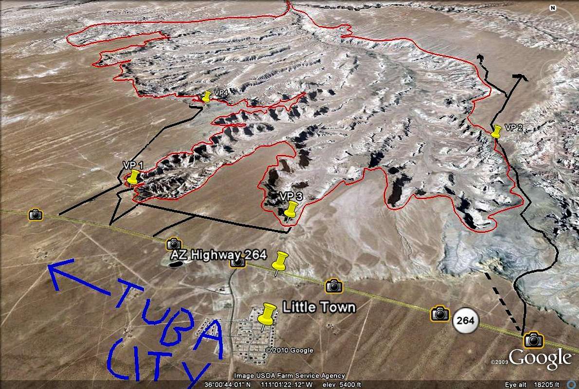
We reaped unexpected results from taking a long detour to the Grand Canyon from Page due to the closure of a section of Hwy 89 which collapsed in February. Instead of going directly south, we had to go southeast via Hwy 160 before turning back west to the Grand Canyon.   But taking the alternate route south, we were able to stop in to see the ancient cliff dwellings of the Puebloan people, dating from AD 1250 to 1300, now protected in the Navajo National Monument.  The Puebloans were ancestors of the current Native American peoples and their dwellings were quite advanced with distinct architectural elements such as roof beams, masonry walls and rock art.   

The ancient dwellings were only accessible by a 6 hour round trip guided hike that didn't start until May.  We were sent along to the Sandal Trail, so called for obvious reasons - it was a short easy hike to a viewing point where we could see the cliff dwellings using a telescope, or better still, through the lens of my camera.  It was quite amazing!  You can see the entire village in the cave.

The largest cave seen from our viewing point on the other side of the valley

Closer...

and closer
The Sandal Trail itself has lots of interesting features including native plants which were marked and identified, including what they were used for.  I loved this tree that looked more like a sculpture than a tree.


On our way to the Navajo National Monument, we stopped into this trading post to make sure we were headed in the right direction.  One of their regulars provided a real western flavour to the photo below.  There were many such trading posts throughout the area - they are equivalent to general stores, some of them more elaborate than others.   


An exceptionally well-stocked "trading post" was the historic Cameron Trading Post, where we spent the night.  It was a great place for shopping, especially for Native American art, with reasonable prices and goods clearly identified if they were made by local Native Americans, made by non-locals, or not made by natives at all.  


But before we got to Cameron, we had quite an adventure off road, which I will talk about in my next post.